


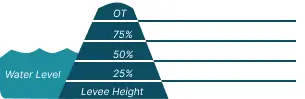
 0 Occurrences
1 Occurrences
8 Occurrences
0 Occurrences
0 Occurrences
1 Occurrences
8 Occurrences
 Maumee Bay and Ottawa River - Toledo - Point Place
 Location
City, County, and State of the levee system. Determined by the
levee alignment location not the leveed area.
Toledo, Lucas County, Ohio
System ID
Unique identifier code for the levee system using 10 or 12 numbers
in length.
2405000020
Operation and Maintenance Organization
Entity responsible for day-to-day management of the levee.
City of Toledo
Floodplain Management
Entities responsible for regulating activities that occur in
areas prone to flooding.
FEMA Region 5
Oversight Organization
Entity responsible for oversight of the levee and ensuring it
is maintained.
USACE - Buffalo District
Last Assesment Date
Last Risk Assessment or Formal Inspection.
1/27/2021
Levee Length
Combine length of all the levee system features including the
embankments, floodwalls, closures where they exist for this
system.
 4.095 Miles
 Average Levee Height
The average height of the levee system. The levee profile viewer
on the mapping window will show the actual levee height values
for the length of the levee if available.
 8 Feet
 Year Levee Constructed Year levee system was fully completed as a flood reduction
project.
 1986
1986 Summary
General text description of the levee system with a
summary of why the levee is there, and the benefits it
provides.
The United States Army Corps of Engineers (USACE) constructed the Maumee Bay and Ottawa River - Point Place levee system in 1987 to manage flood risk from regularly occurring high lake levels. Once completed, it was turned-over to the City of Toledo for operations and maintenance (O&M) contingent on the requirements of an agreed-upon O&M Manual.
The Maumee Bay and Ottawa River - Point Place levee system is located at the western end of Lake Erie just south of the Ohio-Michigan State line. Point Place is a peninsula with Maumee Bay to the east and Ottawa River to the west. The levee system consists of protective structures built along the shores of Maumee Bay, Mudjaw Creek, and the Ottawa River. The three protective structures include: earthen levee, steel sheet pile (SSP), and a combination of levee and SSP wall. The Ottawa River combination structures include 10 stop log closures that allow gaps for pedestrian or boat access to the river. During periods of high water, these gaps are closed to create a continuous line of protection. An interior flood control system was also included in this levee system. It consists of 5 pump stations, 5,500 feet of interceptors, and 2,380 feet of gravity outfalls. The shaded area in the graphic shows flooding that could occur due to levee failure or overtopping during a flood. This shaded area is referred to as the leveed area.
Levee Data:
Total Levee Length = 4.09 miles
Average Levee Height = 8 feet
Leveed Area = 320 acres
Performance: Since construction, water levels have risen more than 2 feet (25%) up the levee 12 times and more than 4 feet (50%) up the levee 4 times. The highest water levels on record were during a high-water event in 1998. The water rose more than 5 feet (62.5%) up the levee and came within 3 feet of the top, threatening to overtop the Ottawa River portion of the project. The levee system has prevented an estimated $41,770,500 of flood damages since completion.
Performance & Condition
General text description of the historical and
anticipated performance of the levee, the people and
property benefitting from the levee and who may be at
risk of flooding, and actions to address areas of
concern.
USACE completed a risk assessment of the Maumee Bay and Ottawa River - Point Place levee system in 2017. The risk assessment found the levee system to be low risk and it is expected to perform as designed. However, there is some uncertainty: the levee has not been fully (100%) loaded, the levee has significant unwanted vegetation, the levee is significantly obstructed by encroachments, and there is minor crest settlement. The storm events have short durations, temporary high-water levels have low head pressure on the levee, and breaching impacts are localized. Water could overtop the levee during a greater than 500-year event (less than 0.2% chance of occurring in any given year). If flooding occurred within the leveed area, there would be a minimal risk to life safety. Still, even 6 inches of moving water could knock a person off their feet and people within the leveed area may not be able to evacuate safely. Residents are therefore encouraged to pay attention to local media reports and follow flood warnings or evacuation orders during times of high water. The City of Toledo has developed an Emergency Action Plan that details the procedures necessary for effective response to a flood event.
Flooding Hazard
Historic Loading by Percentage of Height
 Representative loading associated with historical
flood information as a percentage of the levee height
or overtopping.
Representative loading associated with historical
flood information as a percentage of the levee height
or overtopping.
Representative loading associated with historical
flood information as a percentage of the levee height
or overtopping.
0 Occurrences
0 Occurrences
1 Occurrences
8 Occurrences